Project Menu
Parker Gold Project
Gold, Copper
The Parker Project is located in La Paz County, western Arizona, approximately 14 kilometres northeast of the town of Parker within the Buckskin Mountains Province and lies along the southeastern extension of the Walker Lane gold-copper trend. The Project is approximately 5 kilometres from US Highway 95 (US-95) and is proximal to rail infrastructure at Parker on the Arizona & California Railroad.
The Project comprises 79 unpatented federal lode mining claims covering approximately 6.58 square kilometres and includes the Eagle Nest, Red Breccia and NSW Detachment target areas. The ground historically formed part of what was referred to as the Empire-Arizona Group or Arizona Standard Copper Company, with documented mining activity dating back to at least 1909.

Location of the Parker Project in northwest Arizona relative to the southeastern extension of the Walker Lane gold - copper trend. Refer to ASX release “MULTIPLE CONTINUOUS MINERALISED TRENDS DEFINED AT PARKER”, 12 March 2026.

Historical engineering reports and Arizona Department of Mines records describe the Eagle Nest Mine as multiple structurally controlled copper-gold mineralised structures developed along contacts between quartz-porphyry intrusions and folded carbonate and sedimentary sequences. By the early to mid-20th century, several thousand feet of underground development had been completed, including shafts, tunnels, open cuts and test pits. At Eagle Nest Mine four principal shafts were reported to depths of approximately 100 feet, 200 feet and 600 feet, with ore encountered in multiple workings. Recorded production during World War I and again in the early 1940s involved shipment of copper-gold ore to Arizona smelters, with gold credits contributing materially to shipment value.
Northeast-looking cross section of the Eagle Nest target area (modified after Edward W. Brooke, 1919)
Historical documentation indicates that mining ceased in the early 1940s not due to exhaustion of mineralisation or adverse metallurgical performance, but as a consequence of labour shortages. As Federal infrastructure projects commenced in the Parker district during World War II, miners left the operation for higher-paid government employment, resulting in suspension of mining activities despite the operation having returned to profitability at the time.

Parker Project Regional Geological Map
On 9 April 2026, Magnum reported multiple high-grade rock chip results at the Parker Project, including up to 176g/t Au and 18.30% Cu. Results to date have shown that gold and copper anomalism is spatially aligned with mapped and interpreted structures, with a combined prospective strike length of ~5km, reinforcing the scale and coherence of the Parker surface mineral system.
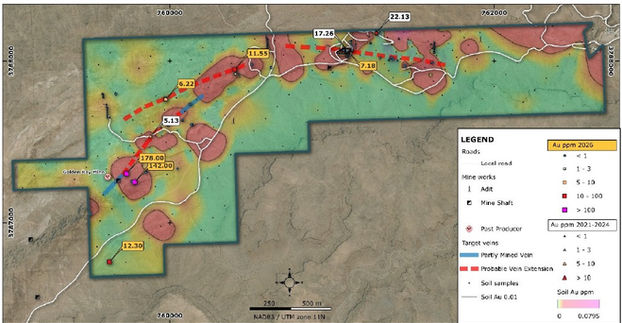
Red Breccia target areas showing 2021-2024 and 2026 rock-chip gold assay values over the 2026 soil gold anomaly, contoured at 0.01 ppm Au. The map shows the location of the new re-assay results received for samples 51059 and 51101, which returned 142g/t Au and 178g/t Au respectively.